Dimension Between Integers: Can We Measure the Length of a Coastline?
By Devandhira Wijaya Wangsa

Measuring Coastlines
How long is the coastline of Hong Kong? Here are the different answers from different organizations:
- Central Intelligence Agency of USA: 733 km [1]
- World Resources Institute: 955 km [2]
- Hong Kong Environmental Protection Department: 1,178 km [3]
What causes these inconsistencies in the data? Lewis Fry Richardson (1881–1953), an English mathematician who studied the possible correlation between the length of shared borders and the chance of a war outbreak, was also puzzled by the same kind of inconsistency [4]. He found that Portugal reported its border with Spain as 1,214 km, while Spain claimed 987 km [5]. This discrepancy led to the discovery of the “coastline paradox.”
Why do measurements of the same coastline differ? Let’s first understand how the measurement of complex shapes can be carried out systematically. For smooth curves (e.g. no corners) defined by mathematical functions, their exact length can be calculated using calculus. However, for jagged, irregular shapes like coastlines that exist in the real world, no simple formula works. Their complexity requires a systematic approach, such as using fixed-length segments to approximate their length consistently and accurately.
Imagine a curve that is smooth but seemingly random (figure 1a). Intuitively, we could use a string resembling its shape. Although this is an accurate method, this approach is practically not feasible when implemented in a computer. This is also not systematic because the string’s shape depends on how it’s placed, making results inconsistent and hard to replicate, especially if we were to apply the method to intricate shapes like coastlines. Instead, we can lay out straight line segments of equal lengths — let's call them “sticks” — to approximate the curve, as shown by the sticks of different lengths in figures 1b and 1c. We then add up the total length of the sticks to get an approximation of the curve’s length. We can expect the approximation to get more accurate as we choose shorter and shorter sticks. Ideally, when the length of each stick is sufficiently short, we get a very good estimate of the length of the curve.
(a) 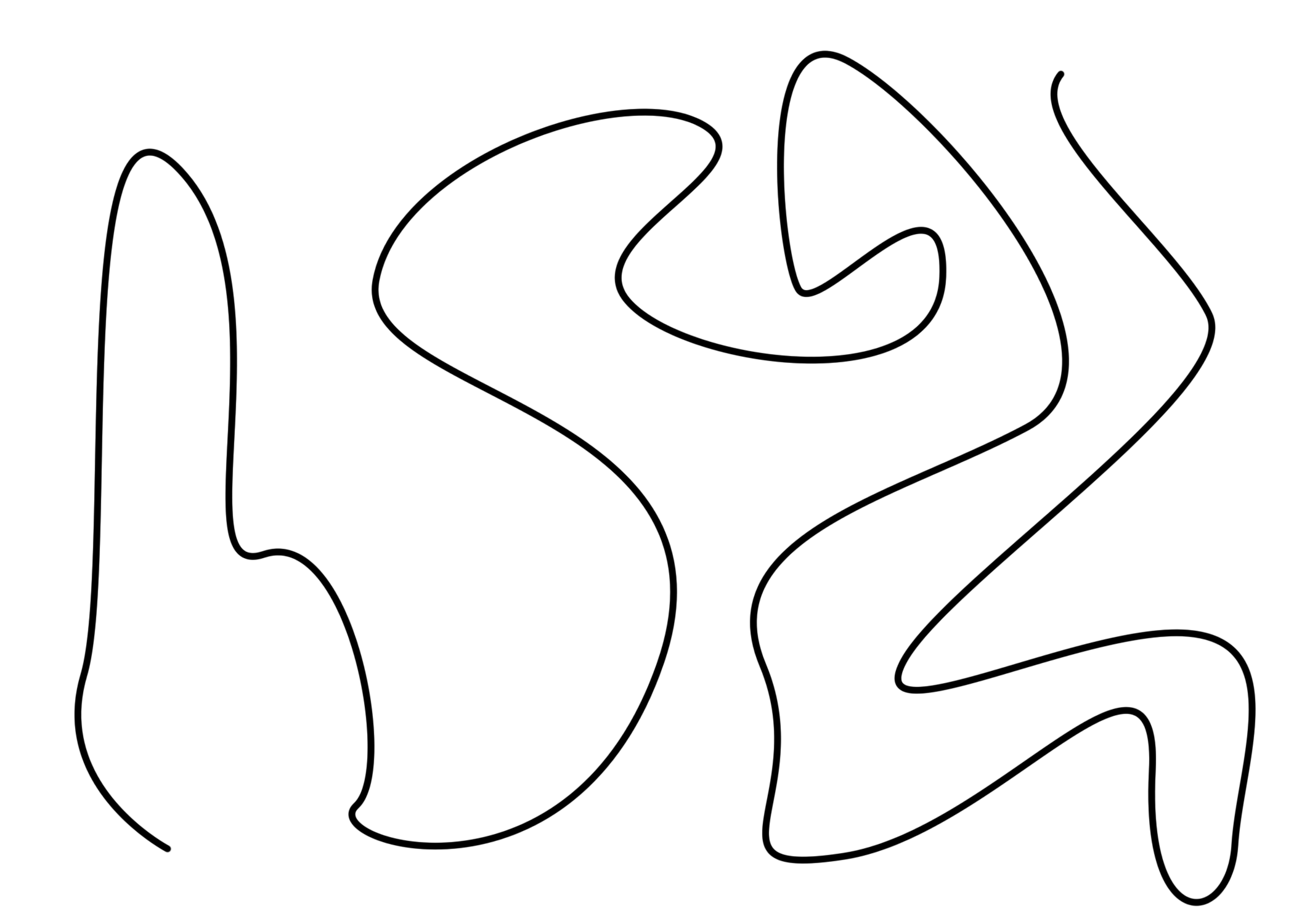 | (b) 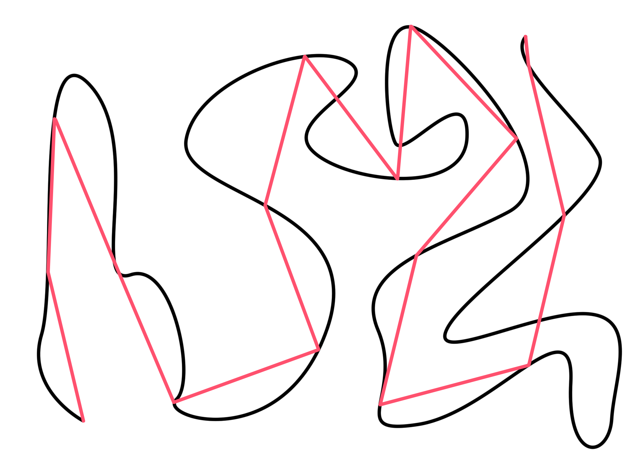 | (c) 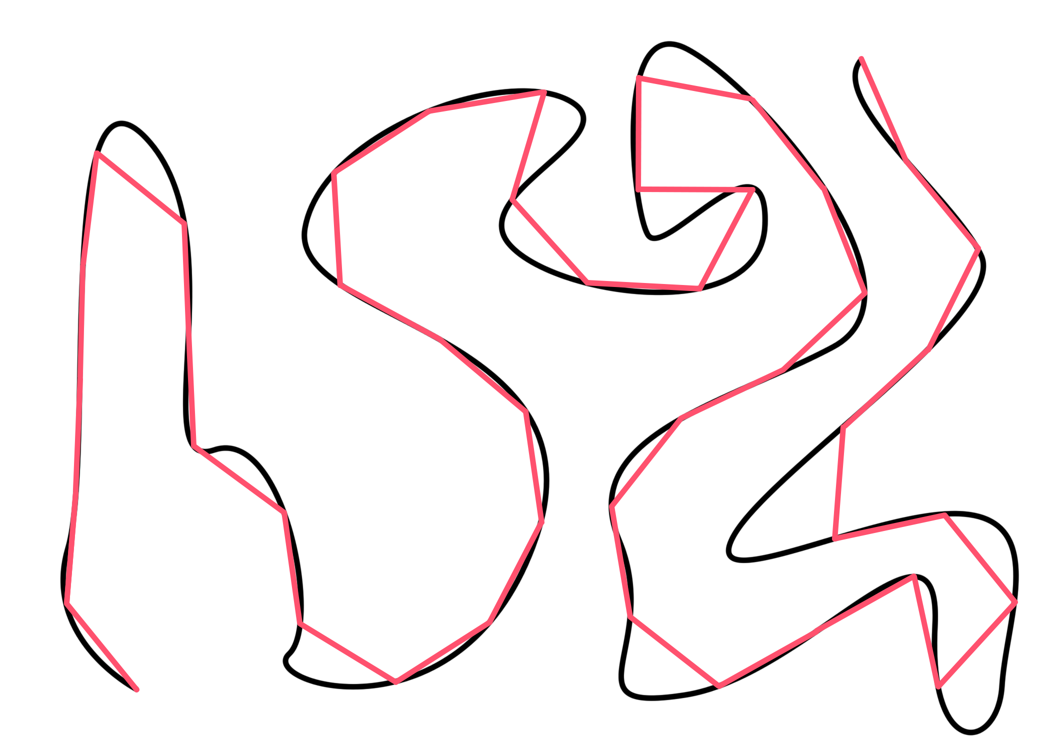 |
Figure 1 (a) A curve that is smooth but seemingly random. (b, c) Straight line segments of equal lengths are used to approximate the curve’s length.
However, when people use this method to measure the coastline of Great Britain, the result is counterintuitive. Using smaller sticks increases the measured length dramatically; using one-meter sticks will result in a total length over 15,000 km [6], which is even longer than Earth’s diameter (12,756 km) [7]! This defies our expectation that finer measurements yield more accurate results, so obviously, coastlines are not something trivial.
Fractals
Figure 2a shows the Koch snowflake, an example that can help us understand what’s going on with the paradox. As illustrated in figure 2b, here’s how it’s constructed:
- Start from a straight-line segment of length 1.
- Divide it into three line segments of equal length (so each line segment has length 1/3), then replace the middle segment with an equilateral triangle’s two sides.
- For each existing line segment, perform step two.
- By repeating this process infinitely, you’ll construct the upper section of the Koch snowflake! To obtain the full shape, simply make three copies of your constructed piece and attach them together in a triangular formation.
(a) 
| (b) 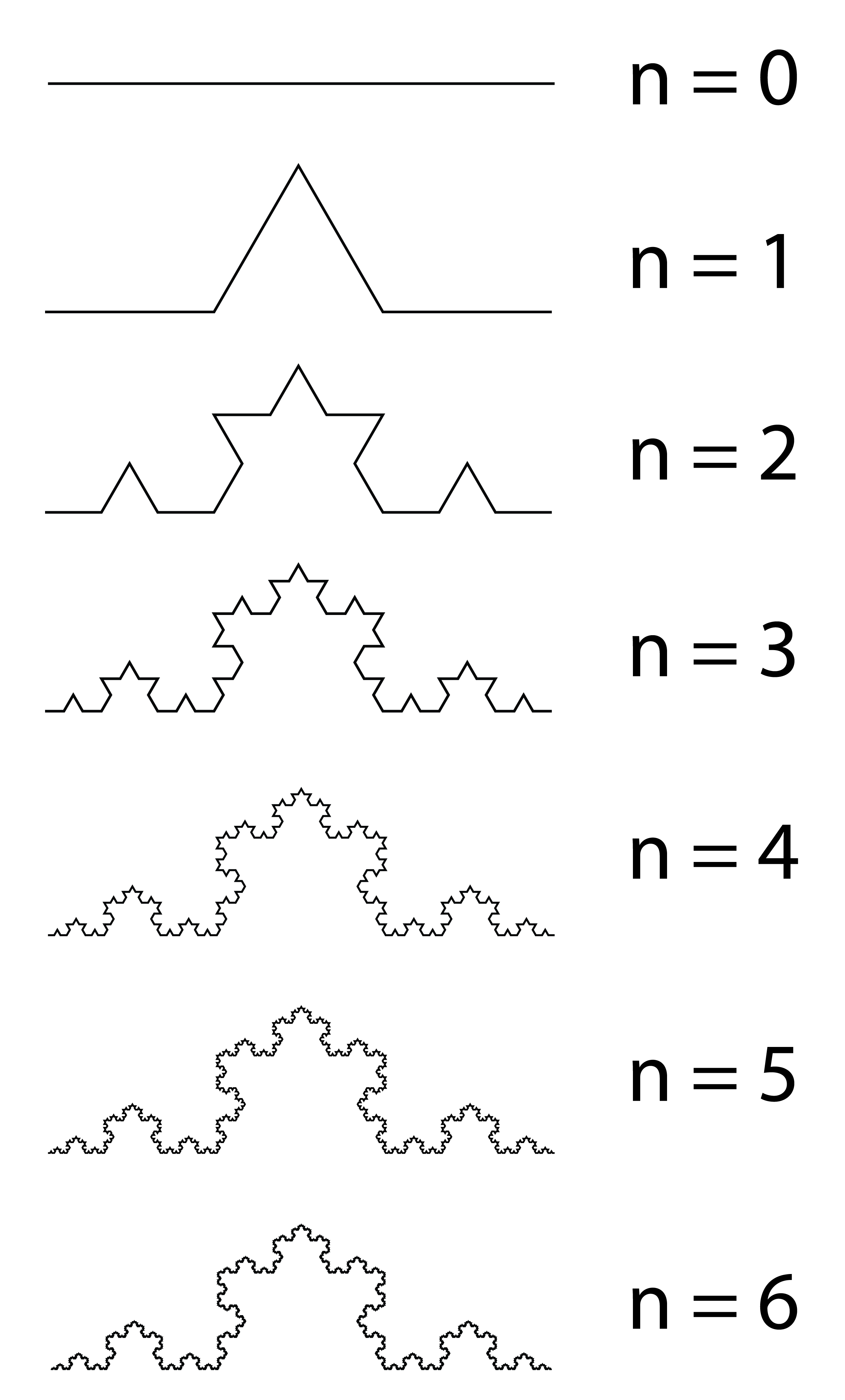 |
Figure 2 (a) Koch snowflake and (b) how it is constructed through a series of iterations.
Unlike a smooth curve, which simplifies when zoomed in, the Koch snowflake remains complex at every scale (figure 3). More details will be revealed when you zoom in more, while the pattern shows similarity at every level, making it a “fractal.” To calculate the length of one of its three sides:
- Recall that we started with a line of length 1.
- The next iteration gives four line segments of length 1/3, making a total of 4/3.
- The third step further divides each line segment into four, giving 16 lines of length 1/9, making a total of 16/9…
Inductively, the total length after each iteration creates a geometric sequence with a ratio of 4/3. Since the ratio is greater than one, the length will go infinitely large. Therefore, the Koch snowflake has infinite perimeter.
Curves like the Koch snowflake that have an infinite length are known as “non-rectifiable curve.” The name comes from the fact that those curves cannot be “rectified,” or “straightened out” like a piece of string and then measured.
(a) 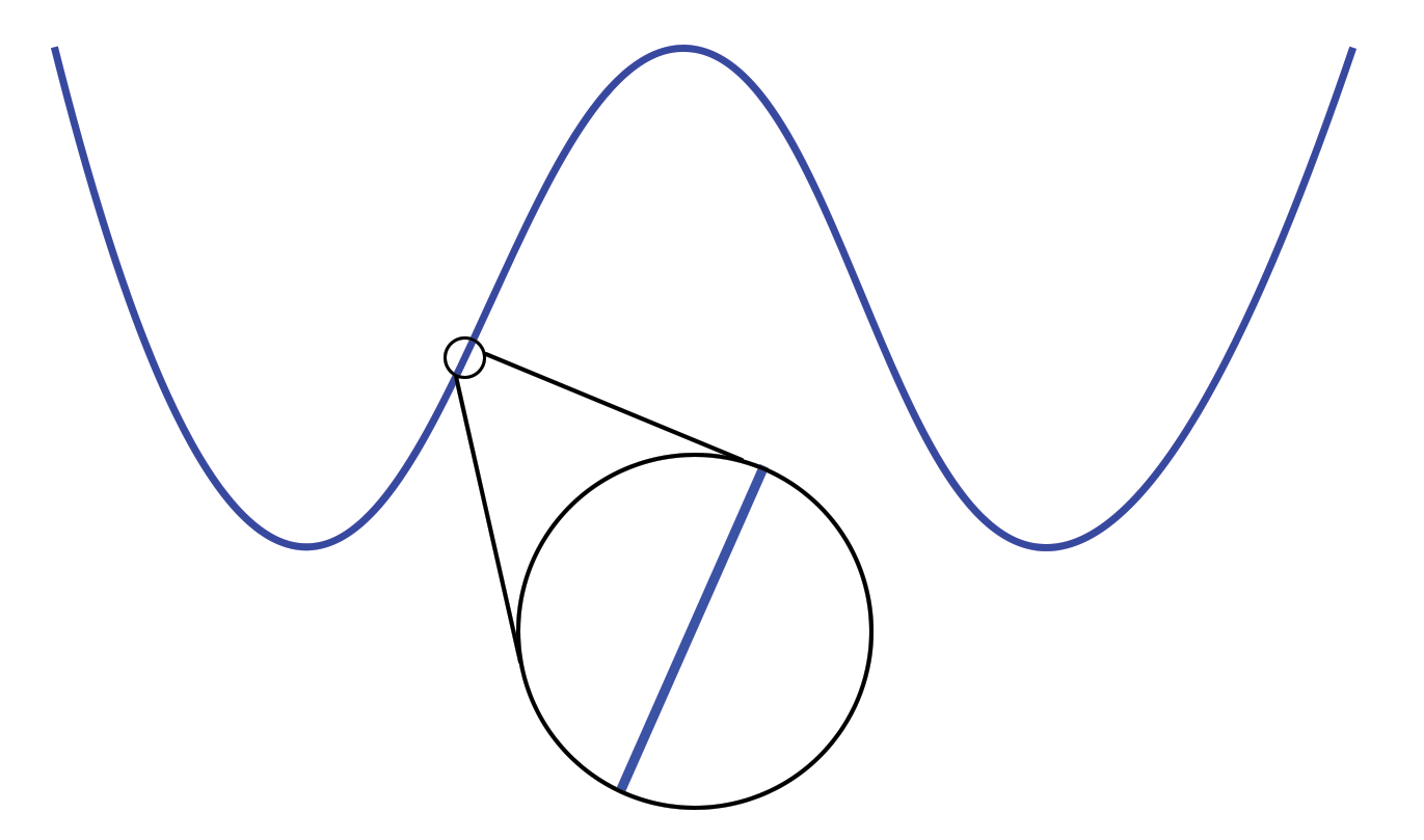
| (b) 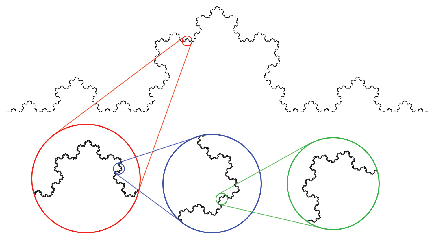 |
Figure 3 Illustrations showing that (a) a smooth curve simplifies to almost a straight line when zoomed in, while (b) the Koch snowflake remains complex at every scale.
Notably, many well-known examples of fractals show “self-similarity” meaning that they look similar at different scales, such as the Mandelbrot set, Julia set, Sierpinski triangle (Sierpinski gasket), and Sierpinski carpet.
Fractal Dimension
Let’s think of this intuitively: Our experience with shapes tells us that any bounded one-dimensional object like line segments have a non-zero yet finite length, but zero area. Meanwhile, bounded two-dimensional objects like surfaces (e.g. a piece of paper), have infinite “length,” as they can be thought of as shapes that consist of infinitely many lines, yet a non-zero finite area. Then where does the Koch snowflake fit? Considering the snowflake as a hollow shape, its infinite perimeter but zero area suggests a dimension between one and two.
This intuitive idea naturally leads us to the concept of non-integer dimension — the fractal dimension, which describes how “complex” a geometric object is.
For example, to find out the fractal dimension of the Koch snowflake, let’s recap how dimension works: Think about a two-dimensional square of length 1, we know that by lengthening its sides by two means that we obtain 4 = 22 copies of the original square, and by three obtains 9 = 32 copies. This is exactly because the square is two-dimensional. In general, scaling, for example, a shape of dimension d by a scale factor of c will give cd times its original copy (try this out yourself with a line or cube).
Let’s take the upper part of the Koch snowflake now. By how the snowflake is constructed, scaling the snowflake by three gives four of the original copies. Therefore, if we need to assign a dimension d, then by the reasoning above we should require 4 = 3d, in other words d = log 4 / log 3.
How about coastlines? Strictly speaking, coastlines are not fractals because fractals are abstract theoretical shapes, but coastlines are fractal-like (that is, having fractal features) to the point where people would approximate their fractal dimension. For instance, the coastline of South Africa, a smooth one in the atlas, has a fractal dimension of 1.02, while those for the border between Spain and Portugal and the west coast of Great Britain are 1.14 and 1.25, respectively [8], meaning that they are more complicated.
Conclusion
After all, can we measure the length of a coastline? The essence of the coastline paradox is the fact that coastlines are non-rectifiable curves since nowhere in real world is perfectly smooth, and when you zoom in on a map, there are always more jagged parts (usually rocks) which lengthen the coastline.
In addition, the length also depends on which standard was taken. As you can imagine, lengths measured at different tide levels can differ significantly because land can become submerged and invisible during high tide. If there is a river, whether and how to include the estuary and its tributaries poses a challenging question. Therefore, a simple answer is: No coastline can be measured objectively.
Math ChallengeLet’s find the area of a Koch snowflake! Let s be the side length of the initial triangle before any “iteration.” Find the area of the Koch snowflake in the first few iterations in terms of s. What happens when we take the iteration to infinity? (Hint: Infinite geometric series) Answer can be found here. |
References
[1] Central Intelligence Agency. (2025, August 6). Hong Kong. The World Factbook. https://www.cia.gov/the-world-factbook/countries/hong-kong/#geography
[2] World Resources Institute. (2012, Apr 19). Coastal and Marine Ecosystems — Marine Jurisdictions: Coastline length. EarthTrends. https://web.archive.org/web/20120419075053/http://earthtrends.wri.org/text/coastal-marine/variable-61.html
[3] Hong Kong Government. (2024, September). Hong Kong: The Facts – Environmental Protection. https://www.gov.hk/en/about/abouthk/factsheets/docs/environmental_protection.pdf
[4] Hayes, B. (2021). Statistics of Deadly Quarrels. American Scientist, 90(1), 10–15. http://www.jstor.org/stable/27857587
[5] Crilly, T. (1995). Reviewed Work: Collected Papers of Lewis Fry Richardson. The Mathematical Gazette, 79(486), 625–628.
[6] Spatial Data Science. (n.d.). The length of a coastline. https://rspatial.org/cases/2-coastline.html
[7] The Imagine Team, Goddard Space Flight Center. (2020, October 22). The Cosmic Distance Scale. Imagine the Universe! https://imagine.gsfc.nasa.gov/features/cosmic/earth_info.html
[8] Mandelbrot, B. (1967). How Long Is the Coast of Britain? Statistical Self-Similarity and Fractional Dimension. Science, 156(3775), 636–638.